

«Kambarata-2»
On the eve of the upcoming explosion to create a dam at the Kambarata-2 hydropower station on The Naryn river, it was decided to use this unique opportunity to carry out own seismological, electromagnetic and geomagnetic observations.
Seismological observations were carried out on a submeridional profile extending from the explosion point to The Alay Valley. The profile was 250 km long. Seismic field was registered by REF TEK 130 digital broadband three-component seismic stations together with Streckeisen STS-2 seismic sensors (points 05, 09, 11, 13) and the CUB seismic stations (points 08,12) which recorded vertical component of seismic field, which were provided by The Potsdam Research Center (Germany).
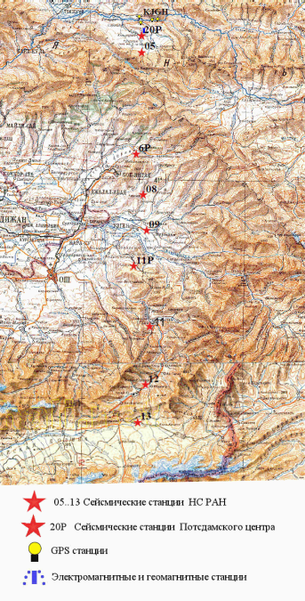
The observation network scheme
In 2008, the Potsdam Research Center installed a network of broadband seismic stations on the territories of Osh and Jalal - Abad regions of Kyrgyzstan. The profile includes three stations of this network: 20P, 6P and 11P.
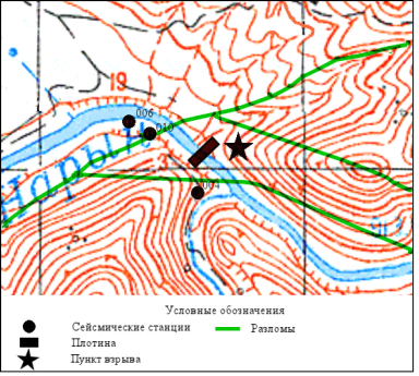
The location of 004, 006 and 010 seismic stations scheme in close zone of explosion
In addition to the profile stations, 8 single-component CUB stations along the second (sub-latitude) profile were installed by the Central Asian Institute of Applied Geoscienses (CAIAG) near the explosion point (from 260 m to 470 m). The results of the observations were combined into a common database.
Based on the results of seismological observations of a pair of stations, assuming that the speed of the seismic wave at short distances is the same for stations installed in the near zone, and does not depend on the azimuth, the moment of explosion was calculated.
A detailed analysis of seismograms at 010 point, located in the Southern Fault zone, showed a series of short pulses that came to the observation point after the explosion. The same picture was observed at 004 and 006points. The presence of pulse signals that occurred after the explosion indicated the activation of the Southern Fault in the form of movements, including in the vertical plane.
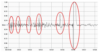
The seismic signal recording (vertical component) in 010 point
The good quality seismograms were obtainedbased on the results of seismic observations at the stations installed along the submeridional profile. The records also contain a signal from the earthquake that occurred after the explosion in the area between 06 and 05 stations, initiated, apparently, by the Kambarata explosion.
.png)
The ΔТ time series graphs: a – complete series of observations (16000 s); b – section of the time series from 6000 s to 6400 s
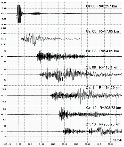
Examples of seismic records of the Kambarata explosion at seismic stations installed along the submeridional profile
The availability of high-quality data made it possible to construct time-distance curves of the first longitudinal waves arrival (P-waves) at the distance of up to 230 km. It is known that explosive time-distance curvesare very rare. They are necessary both for processing seismological data and for studying the structure of the Earth's crust. The new data made it possible to improve the previous time-distance curve obtained back in 1975 on the basis of an industrial explosion during the creation of the Toktogul hydroelectric dam.
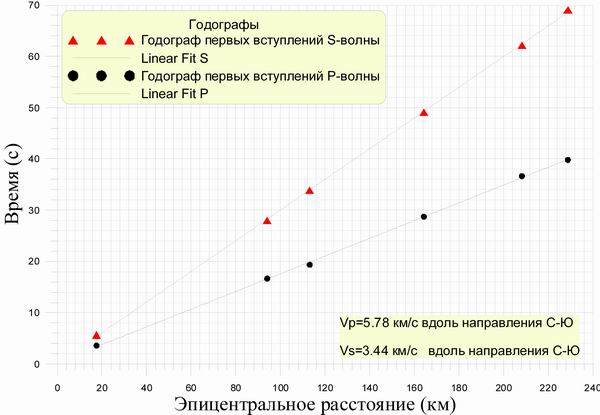
The time-distance curves of the first arrivals of transverse (S) and longitudinal (P) waves at the distance of 230 km from the Kambarata explosion on December 22, 2009
Electromagnetic observations were executed together with the Laboratory of Deep Magnetotelluric Studies (LDMS) with aim to identify the effects from explosion in the Earth's natural electric field and possible change of upper part of geoelectric section in close zone. The works related to LIS were performed using the “ИС – 1” electromagnetic station developed by RS.
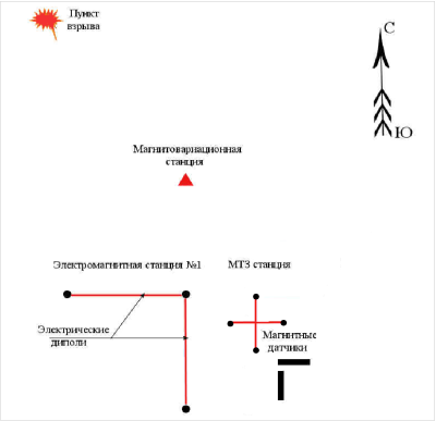
Scheme of observations of electromagnetic and geomagnetic effects from the Kambarata - 2 explosion on December 22, 2009
The discreteness of observations was 800 measurements a second in the band 0 - 10 Hz, the dynamic range - 140dB. On the station the radial component of natural electric field of Earth (Ex and Ey) was registered. A system of orthogonal electric dipoles with a length of about 220 m was used as sensors. As electrodes the brass cores 1 m long were used. The third channel of station was used to register vertical component envelope of electromagnetic field of Earth in atmosphere with the aim to fix exact time of explosion Т0 in the center. For this purpose, the input of the measuring channel was connected to a special broadband (30 KHz – 10 MHz) receiver with a peak detector at the output. Records on all channels of the “ИС– 1” station were synchronized.
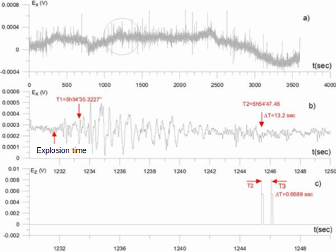
According to the results of observations, a large delay in the reaction of the electromagnetic field to an explosion in the atmosphere was detected ~ 13 sec. At present, we do not know the origin of such delay and the source of this signal correspondently. It was expected that the electromagnetic effects in the atmosphere from the explosion could have a delay of no more than 20 microseconds at the observation point.
Geomagnetic observations were made to determine the presence of piezomagnetic and electrokinetic effects from explosion in low magnetic medium.
Registration of magnetic field was executed before, at the moment and after Kambarata explosion by proton magnetic variation stations “MB–07” with resolution of 0.01nT.The value of the module of the total vector T of the Earth's magnetic field was measured at the stations.The measurement discreteness was chosen as the maximum for this type of the station and was 1 measurement in 4 seconds. One magnetic variation station was located 5.6 km far from the point of explosion (coordinates: 41° 43,425’ N.L., 73° 20,022’ E.L.). Base station was located at the fixed "Ak-Suu" station of Bishkek Geodynamic Proving Ground (coordinates: 42° 36,618’ N.L., 74° 00,594’ E.L.).
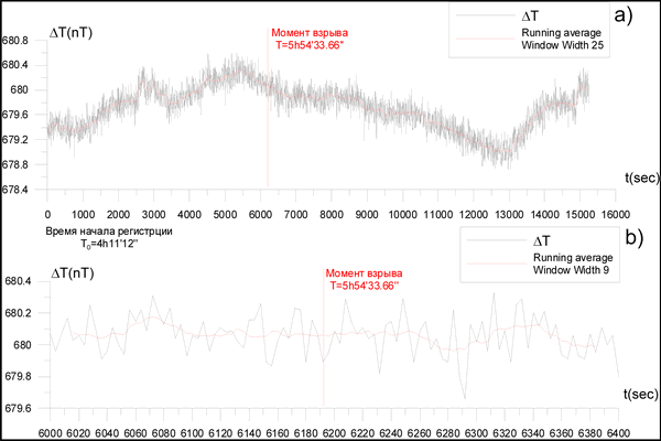
The figure shows that there are no effects caused by the explosion in the ΔТ time series.
In other words, no piezomagnetic or electrokinetic effects from deformation perturbations are observed on weak-magnetic rocks.For this reason, when making prognostic observations and interpreting variations in the magnetic field over weakly magnetic rocks, other mechanisms of their occurrence should be sought to explain anomalous variations.


