We welcome you to the official site of the Research Station of the Russian Academy of Sciences in Bishkek city.
Federal State Budget Institution of Science Research Station of the Russian Academy of Sciences in Bishkek city is the research organization subordinated to the Ministry of Science and Higher Education of the Russia Federation.
The Research Station of RAS engages 57 scientific workers, including 26 researchers, 2 Doctors of Sciences and 8 Candidates of Sciences among them. The overall staff amounts 133 employees.
RS RAS
Installation of additional sites of regional GPS network in area of Mountains Jumgal-Too
Thursday, 25 August 2016 15:54


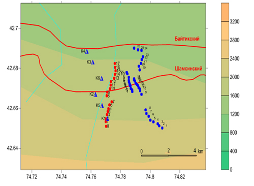
According to the results of scientific research works of 2015 for a large part of the territory of the Central Tien Shan there was obtained general correlation in the distribution velocity of the summary horizontal deformation on GPS and seismologic data for the observation period 1998-2014.
At that, the reduced velocities of near-surface dilatancy and increase in deformation velocities in seismic active layer of the Earth’s crust were fixed in area of Mountains Jumgal-Too (Fig. 1).
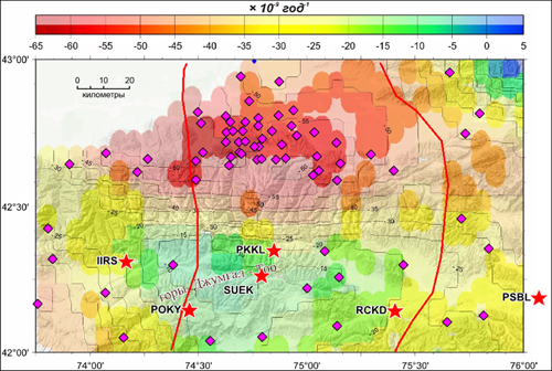
Figure 1. The distribution of total horizontal deformation velocity (dilatancy) for the near-surface part of the Earth’s crust according to GPS data.
Field research under GMTS method
Tuesday, 26 July 2016 14:14
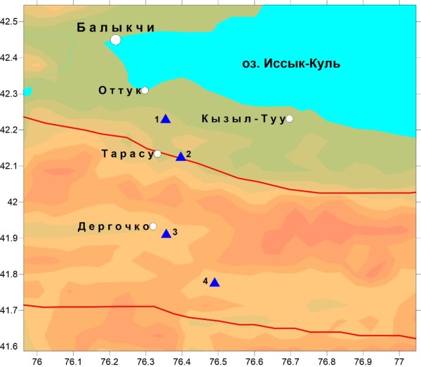
On 11 – 12 of July, 2016, the MTS Group returned to Research Station base after important field works carried out on Dergochko and Karabuk profiles (Issyk _Kul and Naryn regions). Works were performed with the help of Phoenix MTU-5 and MTU-5A measurement complexes. On Dergochko profile (The Issyk-Kul, Naryn Region) works were performed under GMTS method. Two field groups carried out works on 4 observation stations where the registration of MT field long-period variations required long stay. Works were performed at the height from 2100 to 3200 meters above sea level. Time of observations on each point made three days as the result of which the MT data from 0,01 to 10000 sec. were obtained. Works on measuring station launching and MT-field registration were complicated by unfavorable weather conditions (rain, snow, fall of temperature).
Field geological practice
Wednesday, 29 June 2016 09:07
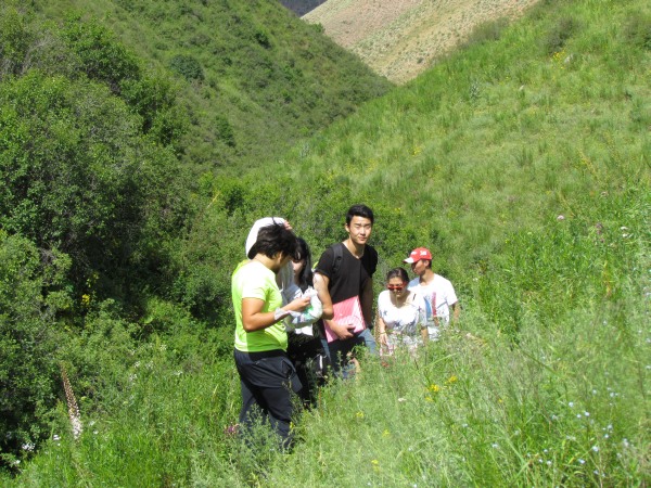 Since 2009 the territory of Research Station RAS is a suitable site for field geological practice conducting by the students of Kyrgyz – Russian Slavic University, specialized in “Complex use and conservation of water resources”.
Regional campaign for GPS point measurements in the territory of Kyrgyzstan
Friday, 24 June 2016 14:03
From May 11 to June 09, 2016 the GPS laboratory staff and transportation motor group has carried out regular campaign for GPS point measurements in the territory of Kyrgyzstan. These works are included in RS RAS research plans for 2016.
Monitoring observations, Laboratory of Deep Magnetotelluric Studies (LDMS)
Wednesday, 15 June 2016 14:31
Further to monitoring observations that have been accomplished by natural electromagnetic field method (NEFM) on the Bishkek Geodynamic Proving Ground (Kentor miniground) since 2012, 3 teams of Group of Magnetotelluric Sounding (GMTS) fulfilled the sounding by AMTS and MTS methods in the period from 16 to 31 May, 2016.
MT observations were carried out on the profiles “Central” (11 points) and "East" (18 points). On the “East” profile (9 – 18 points) works in AMT mode were performed as well. As a result of observations the magnetotelluric curves in the range of periods from 0,01 to 3000 seconds have been received.
More Articles...
Page 31 of 38
Last news
- XVI International Conference of Young Scientists and Students «Modern Equipment and Technologies in Scientific Research» - 2024
- IX International Symposium
- Results of publication activity of staff of the Research Station of the Russian Academy of Sciences for 2023
- XVI International Youth Conference “MODERN TECNIQUE AND TECHNOLOGIES IN SCIENTIFIC RESEARCH”
- Reception of Rossotrudnichestvo in honor of the 300th Anniversary of the Russian Academy of Sciences in the Russian House in Bishkek
Projects
Scientific divisions
Science
Photogallery


